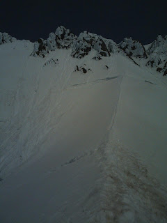
I headed up Mt Hood June 6, 2009 via the south side route for a conditioning hike to the hogsback at about 10,600ft. I left the climbers registration area about 8 am. The Old chute route has changed in the last few weeks. the bergschrund is wide open (See above). Climbers are now opting to traverse from the low point on the hogsback (see picture below) and then ascend directly up the old chute. below the hogsback snow was soft. the old chute was icy, giving those trying to ski from the summit some troubles.


Latitude:45.3306 Longitude:-121.7085 Nearest Location:not known Distance:not known Time:06/06/2009 15:03:02 (US/Pacific) http://maps.google.com/maps?f=q&hl=en&geocode=&q=45.3306,-121.7085&ie=UTF8&z=12&om=1
Latitude:45.3448 Longitude:-121.7048 Nearest Location:not known Distance:not known Time:06/06/2009 14:29:19 (US/Pacific) http://maps.google.com/maps?f=q&hl=en&geocode=&q=45.3448,-121.7048&ie=UTF8&z=12&om=1
Latitude:45.3579 Longitude:-121.702 Nearest Location:not known Distance:not known Time:06/06/2009 14:05:49 (US/Pacific) http://maps.google.com/maps?f=q&hl=en&geocode=&q=45.3579,-121.702&ie=UTF8&z=12&om=1
Latitude:45.3708 Longitude:-121.6991 Nearest Location:not known Distance:not known Time:06/06/2009 13:11:47 (US/Pacific) http://maps.google.com/maps?f=q&hl=en&geocode=&q=45.3708,-121.6991&ie=UTF8&z=12&om=1
Latitude:45.3691 Longitude:-121.7058 Nearest Location:not known Distance:not known Time:06/06/2009 12:39:55 (US/Pacific) http://maps.google.com/maps?f=q&hl=en&geocode=&q=45.3691,-121.7058&ie=UTF8&z=12&om=1
Latitude:45.3583 Longitude:-121.7016 Nearest Location:not known Distance:not known Time:06/06/2009 10:28:42 (US/Pacific) http://maps.google.com/maps?f=q&hl=en&geocode=&q=45.3583,-121.7016&ie=UTF8&z=12&om=1
Latitude:45.3456 Longitude:-121.7045 Nearest Location:not known Distance:not known Time:06/06/2009 09:12:36 (US/Pacific) http://maps.google.com/maps?f=q&hl=en&geocode=&q=45.3456,-121.7045&ie=UTF8&z=12&om=1


