
Roster:
John Petrie (Co-leader)
Gloria Petrie
Scott Phillips
Bryon Snapp
Tim Smith
Robyn Smith
Mike Niemeyer
Jenn Truax
The following Prospectus is from Rick Barry (I also added some GPS route information below)
Round trip distance: ~20 miles.
Total Elevation gain: 10,000’
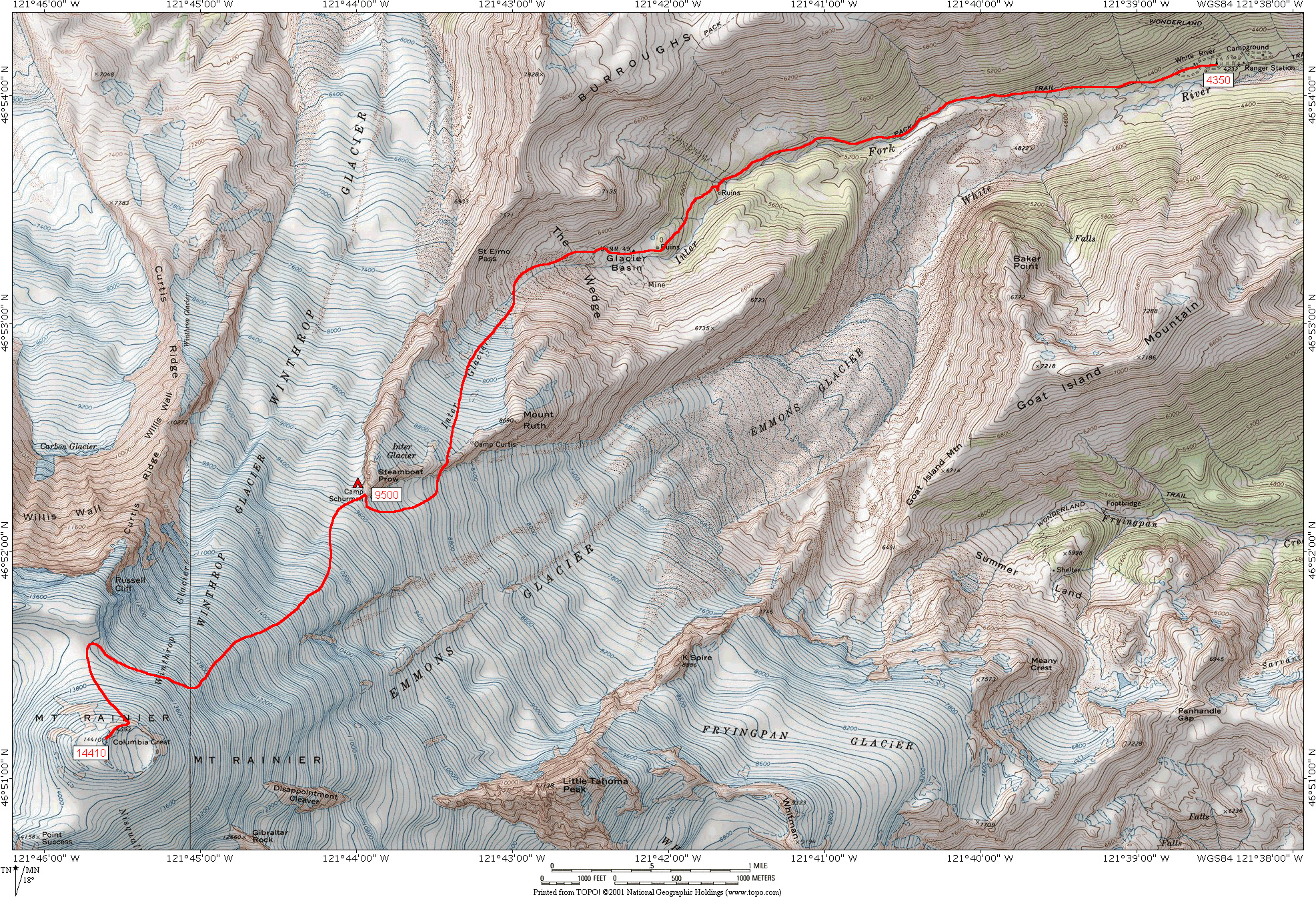
Start: White River Campground 4300’
Camping: Camp Schurman: 9500’
Driving Directions: Drive north on I-5 to exit 68 (about an hour north of Portland) and head east on Hwy 12. Continue about 50 miles on Hwy 12 through Packwood. Just past Packwood turn north onto SR 123/ WA 410 and into the Park. Continue north ~20 miles and take a left onto Sunrise Rd. The ranger station is about a mile down this road. Continue another 3-4 miles and take a left onto the road to White River CG. Total drive time ~ 4 hours. Red Tape: $30.00 climbing permit, all climbers must present photo ID at time of registration.
The Plan: Wednesday, June 18: Drive to White River Campground and spend the night. There is no reservation system at this camp but we should be fine mid-week. It would be nice to caravan up but it’s not a necessity. I’d like to be on the road by mid-afternoon.
June 19: We’ll need to be packed and ready to go by 7:00 a.m. We’ll then drive back to the White River Ranger Station, buy our permits, register, return to the TH and go. The trail winds up the White River for three forested miles to Glacier Basin at 6000’, before breaking out into meadows and moraines. At about 4.5 miles and 6800’ we’ll cut sharply to our left (SW) and head up the Inner Glacier, a small glacier on the backside of Steamboat Prow (Camp Schurman is at the ‘prow’). We’ll rope up and go more or less straight up the Glacier, topping out at Camp Curtis, a small flat spot at 9000’ with bivy sites atop a ridge separating the Inner Glacier from the Emmons. We’ll short rope up this ridge for about a half mile before descending onto the Emmons. Once on the glacier the route hugs the north side of the Emmons for the last mile to camp.
June 20: Rest. Between naps we’ll go through crevasse rescue, passing through pickets etc. We’ll keep this activity very light. Depending on conditions, we’ll start climbing at around 11:30 p.m.
June 21: Showtime! We’ll take some time to assess the route from our high camp and with luck we’ll be able to see a likely course through the upper glacier. The first move is obvious; traverse south across the glacier to ‘the Corridor’ after which we’ll look for the path of least resistance with the focus on getting around or between the two monster bergschrunds atop the Emmons and Winthrop glaciers.
Route description: Since this route is completely on glacier snow, it changes from year to year and season to season, depending on the snowfall, crevasses, and icefalls that determine access to the summit. From Emmons Flats, ascend southerly to the Corridor, a prominent snow slope with fewer crevasses and gentle slopes that rises higher than the rest of the Emmons Glacier. Enter the Corridor between 10,000 and 10,300’ and ascend to 11,200 feet, where the route becomes steeper (30 to 35 degrees). From 11,200 feet, the route may take a variety of directions. Ascend glacier slopes through crevasses and seracs, sometimes traversing onto the Winthrop Glacier. The Winthrop frequently has a smooth shoulder above 12,200 feet, with few crevasses and icefalls. This slope can also be icy and is frequently quite hard; carry pickets for use as running protection. Between 13,500 and 13,700 feet, a bergschrund usually forms at the top of both the Emmons and Winthrop Glaciers. This always creates some fuss, and challenges climbers every year. At any time of the year, it may require down climbing, steep and icy climbing, exposed traversing, and belays to access the final slopes and the crater rim at 14,250 feet. From the rim, it’s a 15 minute walk to Columbia Crest. After the climb, we’ll either remain at Camp Schurman or pack up and return to White River.
June 22: Homeward bound.
Emergency Contacts:
Mt Rainier NP, Park HQ: 360-569-2211 ext 2334 Lewis County S&R: 360-740-1105
In town contact: Kathleen Hanifen, 503-587-8648 (Rick’s wife)
Mike Niemeyer will also be carrying a SPOT satellite beacon.
GPS ROUTE
Here is a link to a topo of the route from a 2003 climb website of Daniel Arndt . The following is an arm-chair GPS route I ran (i.e. not based on on-the ground information) in UTM NAD27CONUS this shows a direct finish - in reality we will need to likely need to traverse around the bergschrund near the top:


