

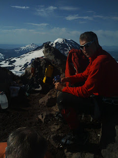
Middle Sister via the Hayden Glacier On June 29th, 2008 our mighty team successfully summited Middle Sister. This was a 13.6 miles rt with about 5100 feet gain (Summit Elevation: 10,047’.) The climb involved a snow approach (past pole creek) and glacier climb to 40 degrees. We had unusual hot weather and a thunderstorm Saturday Evening. We also shared the mountain with another Chemeketen group led by Tim Smith - who also successfully summited with his party.
Trip report: We filled out a wilderness permit and departed from Pole Creek Trailhead (5200’) at about 11 am Saturday. Following the Pole Creek Trail we hiked 1.4 miles to the Green Lakes Trail junction (5840’) at Pole creek. Past this point we began hitting snow on the trail. We turned South for 1.6 miles to the Chambers Lake trail (5740’), and turn Southwest on the Chambers Lake Trail, somewhere under the snow, for approximately 1.8 miles to 6280’ and ascended cross country to an area at the toe of the Hayden Glacier where we camped. We moved up the planned start time for Sunday from 5 am to 3:30 am to avoid afternoon thunderstorms. With a 2:30 am wake up call we departed promptly at 3:30am without crampons, due to relatively soft snow. We followed the snow-covered moraine west towards the saddle, roping up and putting on crampoons for the Hayden Glacier. At the saddle just below the North ridge we ditched crampoons and rope. We then scrambled up the rocky ridge to a point about 700ft below the summit where we roped up again for a steep snow pitch, ultimately arriving at the Summit around 8:15 am (10047’). Unfortunately we found we had been beaten to the summit by Tim Smith's team by only 30 minutes. (Had we not fallen for the hand-made sign "REI promotional giveaway - next glacier" we could have easily beaten Tim's team to the summit) After a half hour summit photo shoot, we quickly retraced our steps back to camp to avoid the thunderstorm moving in. We casually broke camp for a 1:45 pm departure. At about a quarter mile from the cars we started getting hit by large hail, Kevin put his climb helmet back on for protection (see photo). Back at the cars about 3:15 pm. We stopped in Sisters at a mexican restaurant for a meal and summit certificates.
Roster:
1.Mike Niemeyer (Leader)
2. Kirk Kraschel (Leader Assist)
3. Jane Morris
4. Dan Domrose
5. Kevin Kuo
.jpg)


.jpg)
.jpg)
.jpg)


Driving directions: from the State Motorpool lot on Saturday Morning. Drive east on highway 22 to Sisters. from Sisters, 1.5 miles west on Hwy. 242, then 5.6 miles south on F.S. Rd. 15, then 5.3 miles south on F.S. Rd. 1524. (The Pole Creek trailhead road has been snow-covered and closed at the 4,400 ft level but is now open. )
Schedule:
Saturday
7:00 AM -Meet at the State Motor Pool Park & Ride on Airport Rd. (N. of Mission St.)
10:30 AM -Depart Pole Creek Spring Trail Head (5300’/0.0 miles)
11:10 AM -Green Lakes Trail junction (Tr 4070) (5900’/1.4 miles).
11:30 AM -Soap Creek ... Chambers Lakes Trail Jct.(Tr 4074) (5760’/1.9 miles)
12:30 PM -Climbers Trail junction (3.7 miles)
1:30 PM -Arrive at 6800’ camp on Squaw Creek below Hayden Glacier.
Sunday
2:30 AM -Wake up.
3:30 AM -Start climb.
8:15 AM -Arrive at summit. (10047')
8:45 AM -Depart summit.
12:30 PM -Arrive at 6800’ camp on Squaw Creek.
1:30 PM -Depart 6800’ camp on Squaw Creek.
3:10 PM -Arrive at Pole Creek Spring Trail Head (5300’).
3:45 PM -Arrive in Sisters for post climb meal.
5:00 PM -Depart Sisters.
7:15 PM -Arrive at the State Motor Pool Park & Ride.
Participant responsibility: It is each participant's responsibility to be in good physical shape and have the skills and equipment (see below) to participate safely in this climb. A club release will be circulated at the trailhead for each participant to sign.
Required personal equipment

Trip report: We filled out a wilderness permit and departed from Pole Creek Trailhead (5200’) at about 11 am Saturday. Following the Pole Creek Trail we hiked 1.4 miles to the Green Lakes Trail junction (5840’) at Pole creek. Past this point we began hitting snow on the trail. We turned South for 1.6 miles to the Chambers Lake trail (5740’), and turn Southwest on the Chambers Lake Trail, somewhere under the snow, for approximately 1.8 miles to 6280’ and ascended cross country to an area at the toe of the Hayden Glacier where we camped. We moved up the planned start time for Sunday from 5 am to 3:30 am to avoid afternoon thunderstorms. With a 2:30 am wake up call we departed promptly at 3:30am without crampons, due to relatively soft snow. We followed the snow-covered moraine west towards the saddle, roping up and putting on crampoons for the Hayden Glacier. At the saddle just below the North ridge we ditched crampoons and rope. We then scrambled up the rocky ridge to a point about 700ft below the summit where we roped up again for a steep snow pitch, ultimately arriving at the Summit around 8:15 am (10047’). Unfortunately we found we had been beaten to the summit by Tim Smith's team by only 30 minutes. (Had we not fallen for the hand-made sign "REI promotional giveaway - next glacier" we could have easily beaten Tim's team to the summit) After a half hour summit photo shoot, we quickly retraced our steps back to camp to avoid the thunderstorm moving in. We casually broke camp for a 1:45 pm departure. At about a quarter mile from the cars we started getting hit by large hail, Kevin put his climb helmet back on for protection (see photo). Back at the cars about 3:15 pm. We stopped in Sisters at a mexican restaurant for a meal and summit certificates.
Roster:
1.Mike Niemeyer (Leader)
2. Kirk Kraschel (Leader Assist)
3. Jane Morris
4. Dan Domrose
5. Kevin Kuo
.jpg)


.jpg)
.jpg)
.jpg)


Trip prospectus:
Driving directions: from the State Motorpool lot on Saturday Morning. Drive east on highway 22 to Sisters. from Sisters, 1.5 miles west on Hwy. 242, then 5.6 miles south on F.S. Rd. 15, then 5.3 miles south on F.S. Rd. 1524. (The Pole Creek trailhead road has been snow-covered and closed at the 4,400 ft level but is now open. )
Schedule:
Saturday
7:00 AM -Meet at the State Motor Pool Park & Ride on Airport Rd. (N. of Mission St.)
10:30 AM -Depart Pole Creek Spring Trail Head (5300’/0.0 miles)
11:10 AM -Green Lakes Trail junction (Tr 4070) (5900’/1.4 miles).
11:30 AM -Soap Creek ... Chambers Lakes Trail Jct.(Tr 4074) (5760’/1.9 miles)
12:30 PM -Climbers Trail junction (3.7 miles)
1:30 PM -Arrive at 6800’ camp on Squaw Creek below Hayden Glacier.
Sunday
2:30 AM -Wake up.
3:30 AM -Start climb.
8:15 AM -Arrive at summit. (10047')
8:45 AM -Depart summit.
12:30 PM -Arrive at 6800’ camp on Squaw Creek.
1:30 PM -Depart 6800’ camp on Squaw Creek.
3:10 PM -Arrive at Pole Creek Spring Trail Head (5300’).
3:45 PM -Arrive in Sisters for post climb meal.
5:00 PM -Depart Sisters.
7:15 PM -Arrive at the State Motor Pool Park & Ride.
Participant responsibility: It is each participant's responsibility to be in good physical shape and have the skills and equipment (see below) to participate safely in this climb. A club release will be circulated at the trailhead for each participant to sign.
Required personal equipment
Group Gear: The following will be distributed at the trailhead and redistributed periodically during the trip:
- Ropes
- Pickets
- one bivy sack and one sleeping bag will be carried by the party on summit day.
- Radios (FMRS channel 10-5)
SHARED GEAR:
- Tent 1 - Mike and Dan; Kevin - solo tent; Kirk solo tent; Jane solo tent or share with
- cyndeJetboil1 - Dan; Jetboil 2 - Jane
- Shovel 1 - Mike; Shovel 2 - Kirk
Emergencies: In addition to the personal gear & group gear (above) the leader will be carrying a SPOT satellite rescue beacon, GPS and cell phone (503-910-9726.) I will also be sending occasional satellite "check-in" messages to this blog during the trip. In the event of an emergency, I will send out a 911 signal from this device. Local Emergency Contacts: Emergency Contact Information: 911; Central Oregon Emergency Dispatch Center 541-416-6800; Deschutes National Forest, Sisters Ranger District: 541-549-7700. If the party is overdue my local (Salem area) contact is Jackie Niemeyer 503-930-8782. She will communicate with the participant's families in the event of an accident.
For pictures of 2007 climb of middle sister
NAVIGATION:
Here are links to route topos courtesy of the Mazamas: Middle Sister Route and Middle Sister approach.
GPS Waypoints (UTM NAD27 Conus) From trailhead to summit and in reverse...

Here are links to route topos courtesy of the Mazamas: Middle Sister Route and Middle Sister approach.
GPS Waypoints (UTM NAD27 Conus) From trailhead to summit and in reverse...


Trip - Main waypoints via Spot Satellite:
Longitude:-121.7002 Nearest Location:not known Distance:not known Time:06/29/2008 15:25:44 (US/Pacific)
http://maps.google.com/maps?f=q&hl=en&geocode=&q=44.1875,-121.7002&ie=UTF8&z=12&om=1
Latitude:44.1508 Longitude:-121.7469 Nearest Location:not known Distance:not known Time:06/29/2008 11:51:40 (US/Pacific)
http://maps.google.com/maps?f=q&hl=en&geocode=&q=44.1508,-121.7469&ie=UTF8&z=12&om=1
Latitude:44.1483 Longitude:-121.7842 Nearest Location: Elk Lake, United States Distance: 19 km(s) Time:06/29/2008 08:42:03 (US/Pacific)
http://maps.google.com/maps?f=q&hl=en&geocode=&q=44.1483,-121.7842&ie=UTF8&z=12&om=1
Latitude:44.1536 Longitude:-121.7833 Nearest Location: Elk Lake, United States Distance: 19 km(s) Time:06/29/2008 06:39:23 (US/Pacific)
http://maps.google.com/maps?f=q&hl=en&geocode=&q=44.1536,-121.7833&ie=UTF8&z=12&om=1
Latitude:44.1522 Longitude:-121.7733 Nearest Location:not known Distance:not known Time:06/29/2008 05:38:29 (US/Pacific)
http://maps.google.com/maps?f=q&hl=en&geocode=&q=44.1522,-121.7733&ie=UTF8&z=12&om=1
Latitude:44.1521 Longitude:-121.766 Nearest Location: Elk Lake, United States Distance: 19 km(s) Time:06/29/2008 04:36:40 (US/Pacific)
http://maps.google.com/maps?f=q&hl=en&geocode=&q=44.1521,-121.766&ie=UTF8&z=12&om=1
Latitude:44.1507 Longitude:-121.747 Nearest Location: Elk Lake, United States Distance: 19 km(s) Time:06/29/2008 03:27:48 (US/Pacific)
http://maps.google.com/maps?f=q&hl=en&geocode=&q=44.1507,-121.747&ie=UTF8&z=12&om=1
Latitude:44.1507 Longitude:-121.7469 Nearest Location: Elk Lake, United States Distance: 19 km(s) Time:06/28/2008 14:17:00 (US/Pacific)
http://maps.google.com/maps?f=q&hl=en&geocode=&q=44.1507,-121.7469&ie=UTF8&z=12&om=1


