We had a successful summit of Mt Washington on July 18th with everyone summiting and returning safely, if you don't count bug bites. We enjoyed great weather and no crowds, in fact, no other climbers on the mountain - just a few hikers. (Scroll to the bottom for the full pre-climb prospectus. Photos from Chuck Bennett -Thanks Chuck.

Above, 7 am start hiking around a calm Big lake.
Below, Mike and Dan on the approach hike.


Above, Chuck and a nice view of the N ridge approach.
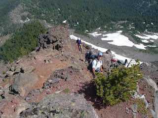
Below, the team ascending the N. Ridge above treeline


Above, Vince and Dan at the top of the second pitch.
(We ended up protecting the entire route in three pitches.)
Below, David, Vince, Tom Mike & Dan on the Summit


Above, summit view looking SE to three Sisters area.
Below, Big lake and our trailhead on the left (west) end of the lake.


Above Tom starting the first (Top) rappel.
Below, Vince assisting climbers about midway on the first rappel
(We did this using two 60-meter ropes to reach the rappel slings for rappel #2.)


David starting rappel #2 (above)
Mike assisting Chuck at top of rappel #2

Everyone safely back to the car (Not counting scrapes and bug bites.)

SPOT Waypoints from this trip:
Latitude:44.3775 Longitude:-121.8806 Nearest Location:not known Distance:not known Time:07/18/2009 19:30:20 (US/Pacific) http://maps.google.com/maps?f=q&hl=en&geocode=&q=44.3775,-121.8806&ll=44.3775,-121.8806&ie=UTF8&z=12&om=1 Latitude:44.3272 Longitude:-121.8439 Nearest Location:not known Distance:not known Time:07/18/2009 18:16:03 (US/Pacific) http://maps.google.com/maps?f=q&hl=en&geocode=&q=44.3272,-121.8439&ll=44.3272,-121.8439&ie=UTF8&z=12&om=1 Latitude:44.3374 Longitude:-121.8387 Nearest Location:not known Distance:not known Time:07/18/2009 17:07:45 (US/Pacific) http://maps.google.com/maps?f=q&hl=en&geocode=&q=44.3374,-121.8387&ll=44.3374,-121.8387&ie=UTF8&z=12&om=1 Latitude:44.3335 Longitude:-121.8383 Nearest Location:not known Distance:not known Time:07/18/2009 16:42:26 (US/Pacific) http://maps.google.com/maps?f=q&hl=en&geocode=&q=44.3335,-121.8383&ll=44.3335,-121.8383&ie=UTF8&z=12&om=1 Latitude:44.3327 Longitude:-121.8382 Nearest Location:not known Distance:not known Time:07/18/2009 16:32:57 (US/Pacific) http://maps.google.com/maps?f=q&hl=en&geocode=&q=44.3327,-121.8382&ll=44.3327,-121.8382&ie=UTF8&z=12&om=1 Latitude:44.3325 Longitude:-121.8383 Nearest Location:not known Distance:not known Time:07/18/2009 11:29:57 (US/Pacific) http://maps.google.com/maps?f=q&hl=en&geocode=&q=44.3325,-121.8383&ll=44.3325,-121.8383&ie=UTF8&z=12&om=1 Latitude:44.3373 Longitude:-121.8392 Nearest Location:not known Distance:not known Time:07/18/2009 09:52:57 (US/Pacific) http://maps.google.com/maps?f=q&hl=en&geocode=&q=44.3373,-121.8392&ll=44.3373,-121.8392&ie=UTF8&z=12&om=1 Latitude:44.3426 Longitude:-121.8441 Nearest Location:not known Distance:not known Time:07/18/2009 09:18:12 (US/Pacific) http://maps.google.com/maps?f=q&hl=en&geocode=&q=44.3426,-121.8441&ll=44.3426,-121.8441&ie=UTF8&z=12&om=1 Latitude:44.3582 Longitude:-121.87 Nearest Location:not known Distance:not known Time:07/18/2009 08:05:44 (US/Pacific) http://maps.google.com/maps?f=q&hl=en&geocode=&q=44.3582,-121.87&ll=44.3582,-121.87&ie=UTF8&z=12&om=1
Latitude:44.3776 Longitude:-121.8804 Nearest Location:not known Distance:not known Time:07/18/2009 07:02:18 (US/Pacific) http://maps.google.com/maps?f=q&hl=en&geocode=&q=44.3776,-121.8804&ll=44.3776,-121.8804&ie=UTF8&z=12&om=1
Pre-Climb PROSPECTUS
Schedule:
Saturday, July 18, 2009 we are meeting at the Salem K-Mart parking lot (25th and Mission Sts) at 5 am, for carpooling, and drive up to the trailhead. Arrive at the trailhead at 6:30am and leave the TH just as its getting light at 7am. The trip should take about 12 hours RT from the TH.
There is a pre-climb meeting on Tuesday evening July 14th at 6:00pm at the Brick in Salem to review required gear and skills and carpooling.
Roster
- Mike Niemeyer (Leader)
- Vince Dunn(Leader assist)
- Chuck Bennett
- Dan Domrose
- David lee
- Tom Spettel
Group Gear will be provided by leader and distrinuted at the parking area:
Radios (On channel 10 code 5), rope(s), rock pro and slings, map, wands, SPOT beacon.
Climber responsibility: This is not a guided trip. You are responsible for making good decisions, assessing risks and knowing where you are during the approach and climb. Carry a compass and map and refer to it when we stop for breaks. Alcohol and any drugs that cause drousiness are prohibited. Please let the leader know if you have a medical condition that could result in yoru incapacitation or that first responders should be aware of if you become ill. You will also be asked to sign a club release. See a copy here.
The Approach:
Take U.S. Highway 20-126 to the Hoodoo Ski Bowl and Big Lake turnoff on Santiam Pass. Turn south off U.S. 20-126 toward the ski area and Big Lake on USFS 2690. Take USFS 2690 to just before Big Lake, turn right at fork and drive to the end of the paved road (Trailhead and camping along lake).
Mt Washington is in the Mount Washington Wilderness in Willamette National Forest. The climb topo below is from Steve Doughtery's website. The hiking trail topo is from Vince Dunn. The main access to its slopes is via the Pacific Crest Trail.

+route.jpg)
The Climb:
This is an easy 5th class climb up the North Ridge of Mt Washington. There are two technical pitches, some scrambling and a couple of rappels involved. You will be climbing on a fixed line for portios of the climb, passing the prussik through the protection. There is a brief route description on Summit Post and a detailed description on Steve Doughtery's website. These vary somewhat as there are a number of route options between the first and last pitches .

Emergency Info:
Leader is carrying a cell phone 503-910-9726 and a SPOT rescue beacon. I'll be sending out OK messages during the climb and can send out a 911 if we run into trouble (or come across another party that needs help.) Willamette National Forest Contact Information 57600 McKenzie Hwy McKenzie Bridge, OR 97413 (541) 822-3381
Linn County Sheriff: 541-967-3950
Detroit Ranger District: 503-854-3366
Links:
Trail topo for Mt Washington (Mazamas website)
Current webcam (view from hoodoo ski area)
Summit Post
Detailed route description from 2007 climb


